Travel Guide
Avatar China Mountains: The Real Locations Guide
Discover the real Avatar China mountains that inspired Pandora, from Zhangjiajie's floating peaks to karst valleys. Plan your visit with exact costs and tips.
Discover the real Avatar China mountains that inspired Pandora, from Zhangjiajie's floating peaks to karst valleys. Plan your visit with exact costs and tips.
Last updated: 2026-08-08
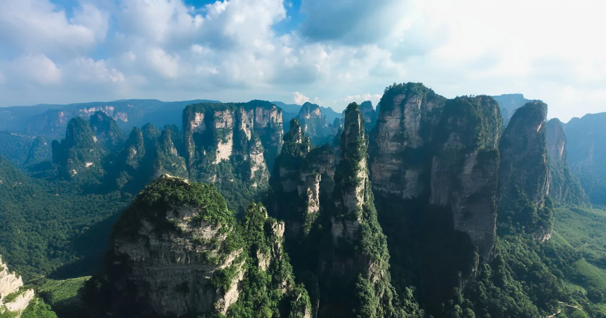
The Avatar mountain effect comes from three geological conditions working together: near-vertical rock columns of unusual height, dense subtropical forest clinging to every ledge, and valley mist that rolls in reliably enough to make lower ground disappear on cue. China has several landscapes that tick all three boxes, and Zhangjiajie in Hunan province ticks them most completely. The quartzite sandstone pillars here were carved over 300 million years by differential erosion — harder rock survived while softer surrounding material washed away, leaving more than 3,000 freestanding columns, many rising over 300 metres in height. Avatar’s production designers have cited China’s sandstone and karst formations, Zhangjiajie among them, as inspiration, and the resemblance to Pandora’s Hallelujah Mountains is not coincidental.
Zhangjiajie National Forest Park, established in 1982 as China’s first national forest park, covers 4,810 hectares of Wulingyuan Scenic Area in western Hunan and forms the undisputed centrepiece of any Avatar-inspired itinerary. The park’s most famous single feature is the Southern Sky Column, a pillar whose summit sits at 1,074 metres above sea level, officially renamed Avatar Hallelujah Mountain by local authorities in January 2010, six weeks after the film’s global release. Getting to the park from Zhangjiajie city takes around 30 minutes by taxi (¥80–120 as of June 2026 — confirm before you ride, per chartered car, city-to-park) or public shuttle bus (¥11–12 as of August 2026 — confirm at the stop, per person, one-way). The four-day entrance pass costs ¥165 per person, or ¥236 with the scenic-vehicle bundle (as of August 2026 — confirm at the gate; full-fare adult), and is worth every yuan — single-day visitors rarely cover even a fraction of the trail network. Plan for at least two full days minimum.
Key routes inside the park divide into three elevation zones. At valley level, the Golden Whip Stream trail follows a 7.5-kilometre creek path through vertical walls for roughly 2.5 hours at an easy pace, with no significant elevation gain. Mid-mountain, the Avatar Valley (Yuanjiajie) area is where the renamed pillar stands and where most photographers set up before 8 a.m. to catch mist before tour groups arrive. The Bailong Elevator — the world’s tallest outdoor lift at 326 metres — connects valley floor to plateau rim in 2 minutes and costs ¥65 (as of August 2026 — confirm at the gate; per person, one-way). At the top, Tianzi Mountain offers panoramic views across hundreds of columns and is reachable by cable car (¥72 as of August 2026 — confirm at the gate; per person, one-way) from the northern entrance.
Huangshan, the UNESCO-listed granite range in Anhui province, delivers a different but equally cinematic version of the Avatar aesthetic — one built on horizontal cloud seas that submerge lower peaks and leave only the highest summits and twisted Huangshan pines visible above the white. Huangshan is not the direct inspiration for Avatar, but its visual logic — islands of rock floating above clouds — maps perfectly onto Pandora. The mountain sits at a maximum elevation of 1,864 metres (Lotus Peak), and summit temperatures average 7–8°C cooler than Tunxi city below. Cloud-sea mornings are most reliable from November through March and in the weeks following summer rain fronts. The cable car from Yungu station to the east steps costs ¥80 per person one-way in the main season and ¥65 during the winter window (both as of August 2026 — confirm at the gate; per person, one-way); the full trail ascent takes 3–4 hours. The mountain entrance fee is ¥190 per person across the main season, which Huangshan defines as 21 January to 19 December 2026; the reduced winter rate of ¥150 applied only from 20 December 2025 to 20 January 2026 (both as of August 2026 — confirm at the gate; full-fare adult). The ticket is not single-entry: one ticket covers three consecutive days with unlimited re-entry, activated by checking in at the ticket office on your first entry, after which returning within the window needs only a free multi-entry reservation rather than a second ticket.
The karst towers of Guilin and the Yangshuo valley represent a lower-altitude, river-level version of the floating-geology effect — not towering above clouds, but rising abruptly from flat alluvial plains and river bends in a way that seems structurally impossible. Yangshuo town sits on the Li River in Guangxi province, about 65 kilometres south of Guilin city, on a low river plain rather than at any meaningful altitude. The limestone karst here shares the same general geological family as Zhangjiajie’s sandstone pillars — vertical faces sculpted by millions of years of water erosion — though the isolated towers top out a few hundred metres above the surrounding plain rather than matching Zhangjiajie’s dramatic heights.
For hikers, Xianggong Mountain offers the single best panorama of the Li River bending through karst towers. The hike takes 40–60 minutes and entrance costs ¥60 (as of August 2026 — confirm at the gate), per person. Moon Hill, about 8 kilometres south of Yangshuo town, is a 45-minute climb to a natural limestone arch — but the scenic area has been closed to visitors since 8 October 2024 for upgrading and renovation, and Trip.com still listed it as temporarily closed with opening hours TBD as of August 2026, so confirm it has reopened before planning around it. No entry fee is quoted here because the pre-closure rate may not survive the reopening. The best season for visiting Yangshuo is September through November: clear skies, humidity drops sharply, temperatures sit at a comfortable 18–28°C, and the morning mist that makes the karst look other-worldly appears regularly without the oppressive heat of summer. April onward into June brings the rainy season, making trails slippery but the vegetation extraordinarily vivid.
Getting to Yangshuo is straightforward: the nearest airport is Guilin Liangjiang International (KWL), about 1.5 hours by bus or taxi. High-speed rail runs directly to Yangshuo station, with Guilin just 20 minutes away and Guangzhou 3 hours south. For local exploration, bicycle rental costs ¥30–80 per day (as of June 2026 — confirm with the rental shop), per bike, and remains the best way to move through the valley. Our Guilin and Yangshuo travel guide covers the full logistics in detail.
Wulingyuan Scenic Area encompasses not just Zhangjiajie National Forest Park but also Suoxi Valley Nature Reserve and Tianzi Mountain Nature Reserve, together protecting over 26,000 hectares of sandstone pillar terrain across northwestern Hunan. Most visitors spend all their time in the Zhangjiajie core, but Tianzi Mountain — the highest point in Wulingyuan at 1,262 metres — offers superior sunrise views across the full column field without the Avatar Valley crowds. Reach Tianzi Mountain via the northern cable car (¥72 as of August 2026 — confirm at the gate; per person, one-way) or a 90-minute hiking trail from Zhangjiajie village. On clear mornings, the view extends across 3,000 individual columns, many still unnamed, disappearing into forest haze.
A logical two-week itinerary connecting China’s most Avatar-relevant landscapes runs from Zhangjiajie (3–4 days minimum) south to Guilin and Yangshuo (3–4 days), with an optional extension east to Huangshan (2 days) on the return. There is no nonstop flight between Zhangjiajie and Guilin; every routing requires at least one connection (commonly via Chengdu, Changsha, or Hong Kong), putting total travel time at well over three hours and fares far above a short domestic hop. Rail is the more dependable link: one daily direct D-series train runs Zhangjiajie West to Guilin in about 7 hours, while the faster option is to take high-speed rail to Changsha and connect onward, with Changsha to Guilin running 2.5 to 3.5 hours by HSR. Huangshan is best reached from Shanghai or Hangzhou by high-speed rail to Huangshan North station (around 2 hours from Shanghai).
Budget benchmarks per person per day: Zhangjiajie runs ¥400–700 including entrance fees, cable cars, food, and mid-range accommodation. Yangshuo is cheaper at ¥300–500 per day with excellent guesthouse options in the ¥200–400 per night range. Huangshan mountain accommodation (on-peak lodges) commands a premium at ¥600–1,200 per night, but staying in Tangkou village below cuts costs dramatically. For travellers who want the landscape without the planning overhead, our soft adventures programme packages the key sites with guiding and logistics handled.
The Avatar China landscapes suit active independent travellers and organised small groups equally well, but each destination punishes poor timing and poor footwear differently. Zhangjiajie’s pillar terrain involves long days on stone-paved trails with significant cumulative elevation change — 15,000 steps on a typical day is not unusual — making it genuinely unsuitable for anyone with knee problems unless cable cars substitute for trail descents. Huangshan is steeper and more exposed, with granite steps running at near-vertical angles in places; poles and grip shoes are not optional in wet conditions. Yangshuo’s karst valley floor is the most accessible of the three, with flat cycling routes and short hikes appropriate for most fitness levels.
None of these destinations require altitude acclimatisation. Zhangjiajie peaks at 1,262 metres, Huangshan at 1,864 metres — both well below the 2,500-metre threshold where altitude becomes a meaningful factor for most people. What they do require is flexibility on weather days. The mist and cloud that make these landscapes look like Pandora are the same atmospheric conditions that close cable cars and reduce visibility on trails. Building buffer days into any itinerary is not optional — it is the difference between the trip of a lifetime and a walk through grey fog.
Prices, ticket rules, opening hours, and transport across China change often — sometimes month to month. The figures in this guide are dated estimates, current as of the “Last updated” date shown above, not live quotes. Confirm current fares, passes, and schedules locally (or with your operator) before you travel.